Beyond Highway 101: An Oregon Coast Hidden Gems Guide for Curious Explorers (Science, Culture & Quiet Places)
The Oregon Coast is not a single destination; it is a 363‑mile collision zone where tectonic plates grind, rivers surrender their sediment to the sea, and human stories go back more than 10,000 years. If you're searching for Oregon Coast hidden gems beyond the crowded viewpoints, this guide will transform how you explore this coastline.
This guide is for travelers who want to move differently here. Instead of chasing the same three viewpoints on repeat, you'll learn how to find quiet pocket beaches, resilient tidepools, and small coastal communities that rarely make the "Top 10" lists - but will change how you understand this coastline. We'll walk through not only where to go, but how to show up: reading tide charts, following Leave No Trace on fragile headlands, honoring Indigenous homelands, and spending your money in places where it actually matters.
If you want this guide in a more tactical format, you'll see invitations to download my Oregon Coast Hidden Gems Explorer Pack - GPS pins, tide-chart cheat sheets, and a planning workbook that mirror how I design trips for clients.
How to Use This Oregon Coast Hidden Gems Guide (and the DISCOVER Framework)
This guide was designed using my DISCOVER Framework, the methodology I use with every client itinerary. It's not about ticking off a list of attractions; it's about transforming the way you move through place.
Here's the simplified version for the Oregon Coast:
D - Define Your Why
Before you book anything, get specific. Are you here for tidepools and marine life, for lighthouses and shipwreck lore, for quiet forest time, or for working waterfront culture? Naming your "why" narrows the firehose of options into a trip that actually feels like you.
I - Investigate Conditions
On this coastline, tides, swell, weather, road closures, and seasonal wildlife patterns matter as much as your packing list. Check tide charts, NOAA marine forecasts, road and trail conditions, and local tribal/park notices as part of your planning rhythm—not as an afterthought.
S - Stewardship First
The Oregon Coast is loved hard. Trails erode, tidepools get stripped, and "secret spots" go viral. Stewardship looks like picking places that can handle your presence, visiting at lower-impact times, and following Leave No Trace in a way that fits coastal realities.
C - Choose Your Base
Fewer basecamps, more depth. Instead of trying to drive the entire coast in three days, pick one or two hubs and really learn them—walk the same beach at different tides, talk to the same barista three mornings in a row, notice what changes.
O - Orient with Tools
Use GPS and paper maps, but also tide charts, harbor webcams, and ranger/visitor center boards. These tools are how you read the coastline in real time, not just follow a static list.
V - Vet Local Voices
Ask people who live and work here—fishers, servers, park rangers, librarians—not just algorithms. They'll often point you toward places that match your values, not just your feed.
E - Expand & Experiment
Build in purposeful white space. An extra hour in a small museum, a spontaneous stop at a boat launch, a detour up a forest road can teach you more than checking one more Instagram-famous beach off the list.
R - Reflect
End each day with three notes: something you learned, something that surprised you, and one way you gave back (economically, emotionally, or physically).
When to Explore Oregon Coast Hidden Gems: Seasonal Guide
The Oregon Coast is a year-round destination, but the personality of the place—and how you should move through it—changes dramatically by season. Whether you're hunting for Oregon Coast hidden gems in winter storms or summer sunshine, timing shapes what you'll discover.
Winter Hidden Gems (December–February)
Winter is storm season. This is when you come for big-swells-from-a-safe-distance energy, dramatic skies, and moody photos that have nothing to do with golden hour. The tradeoff is simple: fewer crowds, more weather.
Spring Hidden Gems (March–May)
Spring is shoulder season: whales, wildflowers, and the first hints of warmth.
Summer Hidden Gems (June–August)
Summer is the classic "Oregon Coast vacation" window, with the most visitor volume and the most family-centered energy.
Fall Hidden Gems (September–November)
Fall is often the locals' favorite: fewer crowds, surprisingly warm days, and relatively calm seas.
If you'd like help aligning your dates with whale migration, tide windows, and your specific "why," this is exactly what I do in my 1:1 Oregon Coast itinerary consultations.
North Coast Hidden Gems: Working Waterfronts & Pocket Forests
For this region, I'm writing from home-field advantage. The North Coast—Astoria, Warrenton, Gearhart, Seaside, and down toward Cannon Beach—is where I walk, watch the river, and test routes before they ever hit a client itinerary.
Astoria Hidden Gems: Estuary, History, and a Different Kind of Riverfront
Most visitors cluster around the obvious spots: the big tower, the Instagram pier, the trolley tracks. That's fine, but if you're willing to wander a bit, you can experience the Columbia River as a working estuary, not just a backdrop—one of the true Oregon Coast hidden gems that most visitors miss.
Look for:
Trip tips:
Hidden North Coast Forest Walks Locals Actually Take
Instead of chasing the same crowded dune overlooks, choose one small forest trail and get to know it.
You're looking for:
Movement guidelines:
Hidden Gem Eateries: Small, Worker-Serving Spots
When you're done walking, skip the obvious chains. Look for:
Spending your money here is one of the most straightforward ways to practice reciprocity: it keeps your travel dollars circulating in the communities whose roads, emergency services, and patience make your trip possible.
Overwhelmed by choices? This is the exact kind of decision fatigue my custom North Coast itineraries are designed to remove. Book a 1:1 Oregon Coast consult, and I'll build a route that matches your curiosity, mobility, and comfort with "unpolished" places.
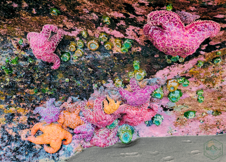
Central Coast Hidden Gems: Tidepools, Basalt, and Marine Reserves
The central stretch of coast is where geology, oceanography, and ecology are loudest to the naked eye. It's basalt headlands, sea stacks, and tidepools—plus small towns bracketed by marine reserves.
Tidepooling Hidden Gems: How to Be a Good Guest in the Intertidal
Tidepools are not "nature's touch tanks." They're neighborhoods where everything is already working hard to survive salinity changes, waves, predators, and heat. Your job here is to witness, not to rearrange. When approached with respect, tidepools become some of the most educational Oregon Coast hidden gems you'll encounter
How to set yourself up well:
What to look for:
Layer in Leave No Trace:
If you'd like my tidepool field notes - species ID cheats, behavior prompts, and a kid-friendly observation sheet - grab the Oregon Coast Hidden Gems Explorer Pack here. It includes GPS pins for tidepool zones that can handle visitation and a tide-chart planning guide.
South Coast: Quiet Beaches & Coastal Forest Corridors
The farther south you go, the more the crowds thin and the more the coastline starts to feel like a series of secret coves and dramatic headlands - some of the quietest Oregon Coast hidden gems you'll find. This is where you lean into deep quiet, long horizons, and the overlap between coastal and river ecosystems.
What to Prioritize:
South Coast Hidden Gem Towns Worth Your Time
 Port Orford
Small fishing harbor, dramatic headland views, Battle Rock wayside. Stop at Redfish for ocean-to-plate seafood.
Bandon
Sea stacks, accessible beach walks, Face Rock wayside. Visit the Bowman Bogs - a working cranberry farm just south of Bandon that offers seasonal tours (yes, really).
Brookings
Azalea State Park, Chetco River mouth, Oregon's "warmest coast." Gateway to Samuel H. Boardman corridor.
Safety Tips for Exploring Hidden Beaches
Indigenous Homelands & Cultural Protocols for Respectful Exploration
The entire Oregon Coast is Indigenous land. That is not a poetic idea; it's a present-tense reality. Many of the viewpoints, beaches, and forests you're moving through sit within the homelands of tribes including - but not limited to - Chinookan, Clatsop-Nehalem, Tillamook, Coquille, Confederated Tribes of Siletz Indians, Coos, Lower Umpqua, Siuslaw, and Tolowa Dee-ni'.
A few grounding principles:
Moving through the coast with this mindset shifts your trip from "consuming" a place to entering into relationship with it.
Resources to Learn More
Indigenous-led nonprofit platform offering an interactive map of global Indigenous territories, languages, and treaties. It highlights overlapping territories to challenge colonial perspectives and foster awareness of Indigenous histories and relationships to land.
Travel Oregon's "Guide to Oregon Indian Country" is a collaborative resource with the state's nine federally recognized tribes, highlighting tourism on tribal lands. It profiles each tribe, their histories, and attractions like museums, casinos, outdoor activities, and public events.
This Oregon Department of Education guide lays out nine core "Essential Understandings" to support the state's Tribal History/Shared History curriculum on Native Americans in Oregon. It covers topics like tribes' presence since time immemorial, their sovereignty, history, governments, identity, lifeways, languages, treaties, and federal policies including genocide.
These resources provide starting points for deeper learning. Always prioritize information directly from tribal nations themselves when planning visits to Indigenous homelands.
How to Plan Your Oregon Coast Hidden Gems Adventure
Let's pull this into something you can actually put on a calendar. Here's a simple structure you can adapt.
3–5 Day North Coast Itinerary: Oregon Coast Hidden Gems Route
Tools for Finding Hidden Gems
Packing for Hidden Beach and Trail Exploration
Accessibility: Hidden Gems for All Abilities
Accessibility is highly variable along the coast, but there are more options than people assume.
 Budget Reality Check
REALISTIC DAILY COSTS (per person, mid-range)
TOTAL: $160 - $290/day per person
Budget more for comprehensive planning support, guided experiences, or premium lodging.
 Planning Timeline
3 - 6 MONTHS OUT
2 - 4 WEEKS OUT
1 WEEK OUT
To make this easier, my Oregon Coast Hidden Gems Explorer Pack includes:
You can grab it here in exchange for your email, and I'll send occasional seasonal planning notes—not spam, not daily "content."
Ready to Discover Oregon Coast Hidden Gems?
If reading all of this makes you feel both excited and slightly overwhelmed, that's a good sign. Finding Oregon Coast hidden gems requires more than a quick Google search—the coastline is complex geologically, culturally, and logistically. It deserves more than "copy someone else's 48-hour itinerary and hope for the best."
My work at The House of Wanderlust is to help you ask better questions of the landscape and then turn those questions into a route that fits your body, timeline, budget, and risk tolerance. I don't book flights or hotels. I build field-ready itineraries that teach you how to move like an explorer, not a tourist.
If you're ready for that level of support, you can book a 1:1 Oregon Coast Itinerary Consult. We'll look at your dates, your interests (from tidepool biology to lighthouses to quiet writing time), and your capacities, and we'll co-create a plan that feels grounded and spacious instead of rushed and reactive.
Ready to transform your Oregon Coast trip from overwhelming to intentional?
If you like guides that read more like field notes than bucket lists, my Adventures page is where I share in-progress routes, seasonal alerts, and behind-the-scenes planning notes.
Budget Reality Check
REALISTIC DAILY COSTS (per person, mid-range)
TOTAL: $160 - $290/day per person
Budget more for comprehensive planning support, guided experiences, or premium lodging.